Admiring The Georgian Alps
Hello everyone, today I thought I would write my article about one of the most fascinating and amazing place in Georgia called as the Svaneti.
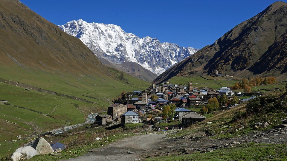
Source View of Ushguli village in Svaneti
It is a place that takes you to your dream world with its natural beauty. Unlike any other region I've written here so far the Svaneti region has so many features that you would enjoy if you love trekking and admire natural beauty.
According to records the entire region of Svaneti is a world heritage site.
Getting to Svaneti is not tough as there are different modes of transportation available from the capital city of Georgia, Tbilisi and also many important cities like Kutaisi, Batumi etc. If you plan to start your trip from Tbilisi you may take a train that leaves to Zugdidi from the Tbilisi Central Railway Station located in Vukzali. The trains are most often night trains. There are mashruthka's or mini vans available that leaves from Vukzali, Didube or Orthachala that may cost around 15Gel one way and it will take around twelve hours to reach Svaneti. There is also a flight available to the administrative district of Svaneti region that may cost around 70Gel approximately for a single way. If you reach Zugdidi by train, there are masruthka's available to Svaneti.
Almost one third of the country's geographical area is covered by the great Caucasus range with some of the highest and complex rugged mountains. This mountain ranges also forms a border between Georgia and the Russian federation. The mountain ranges of the great caucasus has sveral peaks of magnificient height with the highest peak at an altitude of 5068 metres Shkhara and the lowest at a range of 3168 metres named as Dhonguzoruni pass. The average height of the mountains here is estimated to be somewhere around 4000 metres. The caucasus range between the pasi mountain and the kodori range is called as the Svanetian Caucasus. Mtsia is the administrative town for the entire Svanetian region. It is also presented by Lentekhi district which is the administrative town for the lower Svaneti. The caucasus range in this area has many peaks that are snow capped, glaciers, mountain passes and river gorges. Some of the most important mountain peaks in the Svanetian mountain range are Tsurungala that is 4220 metres above sea level, Ailama 4550 metres above sea level, Shkhara which is 5068 metrea above sea level, Janga which is 5060 metre above sea level, Gestolo which is 4860 metres above sea level, Tetlundi which is 4860 metrea above sea level, Tikhtingen peak which is 4620 metres above sea level, Mazeri is 4010 metres above sea level, Chatini which is 4370 metres above sea level etc etc.
Everyone would know about the Matterhon peak in the Alps, a replica of such a mountain is found in the Svanetian caucasus which is paragon and it is called as the Ushba which is at an altitiude of 4778 metres above sea level. There are like twenty mountain passes that are found in the Svanetian Caucasus range. These passes are often lead to the northern side which lies in the Russian Federation therefore they are formally closed.
The region of Svaneti is occupied by the local people called Svan's and they have their own language called Svanuri which has no written form. Therefore Svanuri is added to the already known Megrelian langugage of the former Colchi's kingdom thereby adding it upto the lingustic differences in Georgia. However in the present all the Svans, Megrelians and others are classified under a broad category as the Georgians. Svanians are well adapted to their highland lives. They are well prepared to endure the often changing climate, severe winter of the great caucasus, avalanches, land slides etc. The equipments that they use to survive and work may seeem very primitive but it would be really amazing to see how these people use their tools for their daily survival.
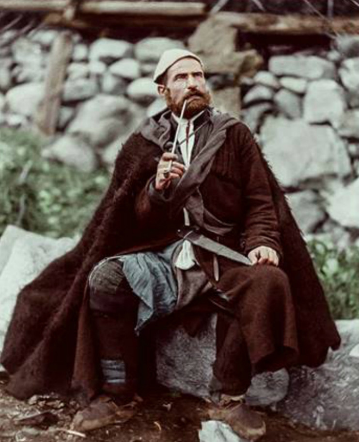
Source An ancient Svan
There are prominent Georgian aplinist who orginated from the Svaneti region. One such prominent person is Mikheil Khergiani under whose name several awards and honours are given. His name was even kept to an unidentified planet discovered by the Soviet Union. There is a museum dedicated to this great person in the administrative town of Metsia which displays his entire life history There are also prominent histories associated with the passes found in the Svanetian mountain range such as the migration of King Vakhtang to Russia during the ancient time.
In the 20th century archeologists identified the fossils of the first primitive humans named to be Homo Erectus. The archeologists also gave the Georgian names Zezeva for man and Mzia for woman. Different cultures that belonged to the very stone age were also identified in this region. This may be considered as a reason why people say "Europe Started Here". From the very ancient time the humans progressively developed like breeding live stock, growing plants for their needs so on and finally dispersed to different parts of Asia and Europe. From the 4th mellinium when the peoples idea about metallurgy increased and started the use of different metals like bronze, copper etc. It was this time when the farmers invented the plough and used animals to plough the land.
In the bronze age the Colchi's kingdom developed prgressively and occupied a most part of the western Georgia. It was this period when the Greek myth of Golden Fleece existed. The entire description of the story I have mentioned in my other article about Samegrelo District of Georgia.
There are numerous literary works written describing the lifestyle and the pride of the Svanian civilization. Strabo has mentioned about the Svans bravery and Vigour. It is said that they dominated over the current part of Sokhumi in the past with their own leader and a council that had 300 people. There is also a hypothesis on why the myth of Golden Fleece arrived which says that the rivers in the Svaneti carried Gold which the locals used to gather using sheep skin and thereby giving rise to the story of the Golden Fleece. Even Plinius has described about this in one of his literary work. At present Svanet is between the two rivers Inguri and Tskhenistsaqli but according to the myths the Svans had a vast empire. Their kigdom consisted of the northern part of the Colchis kingdom that extended between the Rioni river in which the battle ship Argo saied and the river Kodori. The mountain ranges of this region has supplied the ancient rulers with an abundant amount of metals which becomes very obvious from the axes, arrows, other weaponeries used by them that were found during archeological excavations. A noteworthy fact that is obtained from the archeological excavations is the numerous amount of coins that belongs to the period of Alexander the Great. that were found from the Svaneti region. This brings out the fact that both the Colchis Kingdom and the Svaneti Kingdom were in a close contact. In the late 19th century an English expedition team used the same route mentioned in the Greek Mythology to explore the past history.
The Svanetian Caucasus has a tremendous flora within its boundaries. The region's terrain is highly varied ranging between glaciers, mountains, plateaus etc. There are also a wide variety of herbs that are used traditionally to cure a wide variety of diseases. This mighty caucasus range protects Georgia from the influence of freezing cold climate that is found among several parts of Russia. There are wide varities of trees ranging from the alpines at the highest part and the coniferous trees on the lower parts. The trees also include hornbeams, lime trees, ash trees, elms, maples etc. From the very ancient times the wide variety of hrebs found in the forests of this region are used to prepare drugs for a variety of diseases. In the ancient times they were also used to prepare some magic drugs and lethal poisons. Even in the Greek myths the poisons extracted from the herbs of this forests where used to tranquelize the dragon that was gaurding the Golden Fleece.
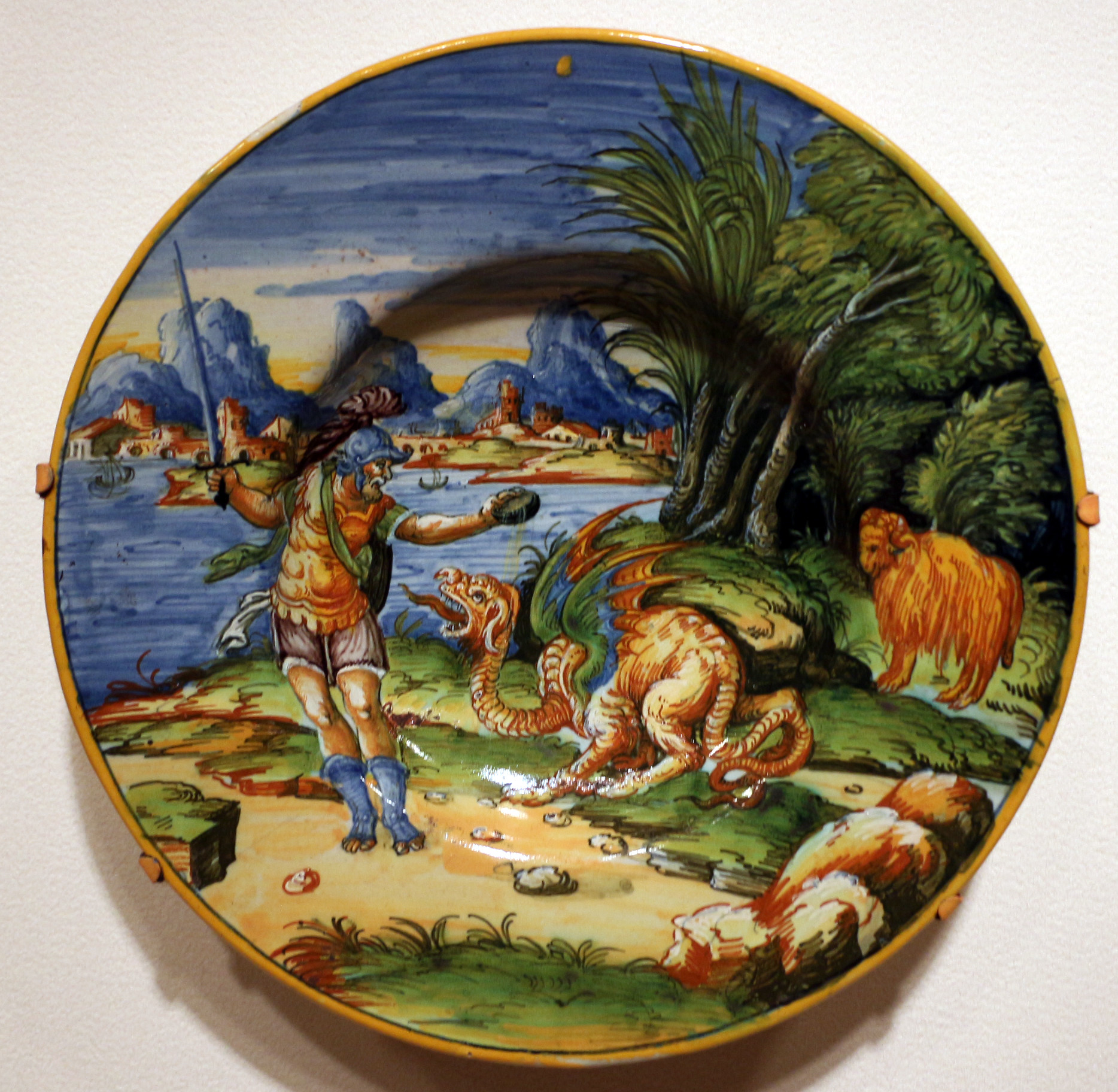
Source Painting of the Golden Fleece myth
I guess its enough about the history and geography of the place and now it's time to speak about what's there to do in the place. The Svan's have their own language and this makes it difficult for the tourists to communicate with the people. Most of the Svaneti people doesn't really understand Georgian and a very few can understand Russian. English is still a question mark in this region with only one or two guest house owners and tour guides who are capable of speaking very basic english. Once in Svaneti there are wide variety of trails to trek through this entire region out of which some I will describe here.
The Tviberi Trail
The Tviberi Trail which is a short path that takes about six hours to complete extending between Zhabeshi village upto Qvitlodi annd Tviberi Glaciers. The starting point of this short trail is the bridge over the place where the Tviberi and Tsaneri rivers meet after which the river gets a common name called Mukhara. The route markers that are placed along the route guide the tourists all the way along their travels. The start point for the trail is marked with a yellow stone painted S. On the left bank of the river one could see a tower following the path which could lead to a valley called Karieli valley. The valley which is at an alttitude of 1620 metres above sea level marks a gate upon which stood a stone fort in the past. There are ten different mountain passes such as Lekhziri, Bashili, Laskhodari, Qvitoldi etc found in this trail. There are eight narrow paths that joins together near the river to form a single path. There are two gates that are constructed which also now serves as path marker for people who trek in this region. After a small distance the path splits into two, one moving towards the west and the other following a small stream and the trail follows the stream. This area has also dangerous falling stones in its path and therefore a strict caution has to be maintained. Those areas that are prone to stone fall are marked with yellow stones again. The path moves through bushes of raspberries and travelling after a few metres you would find a pine tree marked with a yellow line from where one could have a good look at the village from which the trail started. The trail follows and travelling further for an hour will lead to a second gate which makes a border between the Karieli valley in the back and in front mixed forest areas. The trail subsequently take us to a massive cave formed from boulders. Moving further will lead to a meadow that was formed from an avalanche and depending on the season the meadow may or may not be covered with snow. The meadow leads to a place where a waterfall orginates and near by the waterfall there is a path that is called as Mashelani by the people of the area that has many berry trees. As we go further up at a level of 1920 metres above sea level we can find another waterfall that is so magnificient. From here you may see the rich nature of the Svaneti region. Now comes a difficult part in the trail that is so difficult and steep as we had to cross the stream of Lukaia and reach the other bank. The next path marker in the route is Diebachi cliff where a cave called Hunter's cave is present. At this point we will see a snowy slope and if we travel further to a short distance we will reacha rocky area where there is a rock painted "F" which means the Finish Line. At the finish line there is the Tviberi Pass. In the past time the region was rich in glaciers however at present the glaciers have gradually reduced in size and now confined to the hills.
The Ushba Trail
The next trail is named as the Ushba Trail which holds the name of famous Ushba mountain which resembles the Matterhorn mountain in the Alps. The route takes about eight to nine hours to complete, starting at an altitude of 1600 metres above sea level. This trail also starts in a bridge over the river Dolora in a village called Tvebishi. Here again there is a start point painted in yellow that marks the start of the trail. The trail follows the right bank of the river with a fence on the opposite side. Walking on the route will lead us to a stream that is dry mostly which on moving further will lead us to a bushy ground. As we move forward in the path the mountains that are in front of Usbha covers the main Ushba mountain. The path crosses the right tributary of the Dolora river where we can see the mountain called Mazeri. Further uphill we may have to cross another tributary of the same river where we are able to see some snow covered mountains towards our sides. There is steep path that moves down at this point and we finally we reach a plain surface at height of 1800 metres above sea level. Following the path for two additional hours will lead to a plateau at a level of 2400 metres above sea level which forms a source of two beautiful waterfalls. The next part is quite difficult as we have to cross three small waterfalls and go up to the point where a main waterfall descends. The trail leads to a large boulder path that moves uphill which leads to a log bridge that crosses the same river again. Crossing the bridge will take us to a forest where we can find shelters made up of logs. The path again divides here and the original trail follows the path of Dolora valley which leads to the Becho pass. Walking a further longer will take us to an avalanche prone zone where there is also a forest in a ledge. There may or may not be snow depending on the season and the trail has varying features like grass and stones. At this level we could see very well the path that we have crossed. The route now turns and agains follows a steep ledge which leads to the steepest part in the trail. The trail now has rocky path covered by grass which makes it difficult to recognize if the stones would roll around or not. The path runs through forests and after a short time we may have to cross another waterfall. Walking a short distance will make us cross a stream made by another waterfall after which we can see the points of origin of all the waterfalls that we had crossed in our path. There is a rounded ledge that is needed to follow to continue our path which follows a stream created by the strongest waterfall in the area. This route leads to the source of the river from the Ushba glacier where camps of mountain climbers are found. There is a Finish marker placed here which denotes the end of the path and finally one may find themselves situated in the middle of all the gigantic peaks of the Svanatian Caucasus. Its advisable to have all those equipments needed for a quality hiking during this trail.
The Shkhara Tail
The next trail that is available is the Shkhara Tail that helps us to admire the beauty of the Shkhara mountain that is the tallest among all other peaks in this region. The trail by itself begins in one of the most remote and scarcely populated region in Svaneti called as the Zhibiani. It requires about six hours to complete the trail during which one may witness bot the natural beauty of the place and also the antique structures that are found here. The start point is in the village which is located at an altitude of 2080 metres above the sea level. This region is also houses a prominent place of worship called Lamaria in which is situated the Church Of Saint George. After walking a small distance there is a bridge that one must cross in order to reach the right bank of the river called Inguri. Walking in the direction that is opposite to the direction of the flow of river follows a mountain road that is really poor. There are numerous yellow markers that are found on the route that marks the path of trail. As the trail continues one must cross the tributaries of Inguri river one by one after which we may have a good look at the mountain Shikhara. The entire route is to reach the base of the Shikhara glacier from which two streams originate. At a much higher altitude the Inguri river is joined by another strong river called as Paqvlashi. Moving further we will find a small lake opposite to the river Inguri at a height of 2100 metres above sea level. Then again we may have to cross a small stream after which the path splits into two with one leading to an open land and the other is the route to follow. Continuing the path there will be a shepherd's camp beside a large pile of rocks. A stream from Namqvami glacier joins the Inguri river at a much higher altitude which we follow that leads to a forest. The ground is extremely rocky but covered by grass that hides up all the rock. At a level of 2390 metres above the sea level the path comes to an end where one can witness the glacial streams that serves as a source for different rivers. Inguri river is one of the important landmark in this trail.
The Chalaadi Trail
Chalaadi Trail is a path that leads to the Chalaadi glacier located in a peak called Chatini. The entire length of the trail is around 6 kilometres and it may take six hours to complete the trail. At the very end of the town of Mestia on the banks of Mestiachala river the trail starts with a marker painted in yellow in a wall as Start. The region as mentioned on the wall is about 1490 metres above sea level. Towards the north there is a cliff called Dalaqora cliff below which the two rivers Mestiachala and Chalaadi join together. Our paths takes us to the Chalaadi glacier that marks the beginning of the path. The route now is a dirt road that doesn't have a single sign for the next kilometer unless it reaches a village called Lavladashi. The path takes us further near the cliff and we may see a sign called 7 where there is drinking water available. There is a dike dam which denotes the place where the Mestiachala river joins the Chalaadi river. Towards the left mount Chatani at the same time Chalaadi glacier is also visible. The trekking is towards the glacier and the route follows which leads us to a primitive hanging bridge located at a height of 200 metres above the place where two rivers join. As we cross the river we reach the right bank of the river Mestiachala and follow our path that takes us into a forest where border gaurd post is visible but we continue through the forest to enter the chalaadi valley. Now we begin following the left bank of the river Chalaadi in the direction against its flow. There is a split in the route and there are signs that makes us follow the left route which leads us to some remains of an old hut. The route follows a rocky area where there are signs from which the mount chatani can be seen. At about 1900 metres approximately above sea level the path comes to an end where one can see the Chalaadi glacier which is a source to the Chalaadi river. This trail is not that dangerous and difficult compared to others.
The Buba trail
The next important trail to be explored will be the Buba trail starting from an altitude og 1750 metres above sea level. Shovi is a place located on the banks of a tributary of an important river called Rioni. The tributary is called Chanchakhi which is supplied by Caucassian glaciers. The most important rivers that arise from the glaciers are Tbilisia and Buba. The region of Shovi also produces different types of mineral waters that is known to cure many diseases. The trail begins in a hotel called Mamisoni in Shovi that follows the bank of a river called Burburs for the first few metres. There is also an acidic water spring that is found in the route where the path turns north and splits into two out of which you may have to follow the route to the right. There are remains of an old church here in this path amidst a forest. The path gradually gets leveled and leads to a field. There are number of shpeherd huts at this zone. Following the path you may have to cross a stream and move in a uphill path. The route ends at a height of 2300 metres above sea level which is marked by a sign on a huge stone. The near by areas are free of danger and you may move around for a while and explore things.
The Latphari trail
The next trail in list is the Latphari trail which is found in the lowest mountain pass of the Svanetian Cuacasus range. It is the easiest trail among all and it is used since the past for travelling, commercial and other purposes. During worse climatic condition the pass serves as an alternative route for the locals to communicate with the rest of the country. The path would take 12 hours to complete and it starts in a village called Davberi. It is the place where the river Enguri and its left tributary joins each other. The trail starts at an altitude 1760 metres above sea level. The path follows a small distance where you may find a natural spring to store water and moving further the route splits into two. To complete the trail you may have to follow the left route and move further up where the road becomes leveled serving as a grassland at the end of which there is a forest. At this point different peaks such as Mout Mishuri, Ushba are visible. The route moves further upwards to the Latpari range. At the highest pont of this pass there is a small lake along with a shelter at the end of which the path descends into an area which has some shelters of shepherds. Further moving downwards you may reach the gorge of Tskhenistskali and a lake on a mountain becomes visible. The path now takes you to the lake in a coiling path. The path first moves into a field followed by a forest that leads to the village of Chvelpi. There are two small huts that breeds live stock and moving further you will join the sleigh road that finally ends in a main village called Chvelpi.
The Zeskho trail
The next trail is called the Zeskho trail which joins the adjacent mountain regions Svanet and Racha. This trail is being used since the past for moving in and out of Svaneti. The name Zeskho comes as the trail starts from a village in lower Svaneti called as the Zeskho. It follows a river called Zeskhura which takes to a bunch of shepherd huts and moves further reaching a ridge called Lapuri ridge located at an altitude of 2200 metres above sea level. The path becomes a bit tough at this point and it continues to descend to the Tskhenistskali river. The path then continues to move upwards to the Vatsistsveri pass. In this area there are number of wild animals that could be seen at the same time fishing can also be done in the river. Moving through the mountain pass will take you to Rioni gorgr in Rancha. The pass now moves down along the ridges of the lakes and continues further into shepherd shelters thereby finally into the village of Ghebi ending up the trail.
The Mestia Tsvirmi trail
Mestia Tsvirmi trail is another one that can help you explore the beauty of Svaneti. It will take you thriugh the beautiful Enguri river valley. The trail begins in the center of the administratie town of Mestia and crosses the rivers Mestiachala and Mulkhura. Then the route passes the museum at Metsia and goes upward through the forest along a dirt road. Walking for a long distance in this road will take you to a place where the road splits into two with the left one making a sleigh track to the Mount Zurulidi and the right to the Ieli village. The route which we need to follow is the one that takes us to the village of Ieli and this is the only place in this whole planet where gold sedimentation process is carried out using sheep skin as in ancient times. The dirt road ends at the Ieli and there is a small path that leads to the woods where it splits into two paths again and you should follow the right one that would take you to a stream. You should then cross the stream and follow the route which will take you to the village of Tsvirmi in a sleigh road. This village is located at an altitude of 1900 metres above sea level. The village has lots of churches and cultivates massive amount of potatoes. There is also a family hotel available at this village. From Tsvirmi the trail continues towards the Ugviri pass in a dirt road and after a considerable distance the route crosses a highway where there is a signpost and from here one may hike along the highway to Metsia or further continue on a trail that moves into the forest and climbs up that takes you to the village of Adishi. Even from this point there are two variants available. 1] you can move into Zhabeshi and thereby hike to Metsia or 2] Hike through Adishi to Ushguli both of which we will see in detail later.
The Mestia Tskhakzagari Koruldi Trail
The next trail route is circular that will take us around the history of the Svaneti region. It is called as the Mestia Tskhakzagari Koruldi Trail. The trail can be covered in 8 hours however a shorterned route that can be completed in 5 hours is also available. The path for this trail agains begins from the centre of Mestia. It moves through a street that takes you into the nearby neighbourhood where it crosses a stream and turns to the right. The path now moves into the forest to the mount Tskhkkakezagari where a view of all the high peaks can be seen. This is the endpoint if you are following a shortened route where you move along the Lanchvali road to Mestia or else if you want to continue the long route you should follow the signs called Lamajaa. At Lamajaa there is another post that marks the direction for the further trail which will take us to place with huts where pure dairy products are available. This meadow region further takes us towards the lake of Koruldi. There are numerous wooden sign posts in the route that makes hiking easier. At 2740 metres above sea level the lake of Korulidi now becomes visible to your eyes. The trail from the lake descend down to the first sign post where you can follow the way back to Mestia through Lanchvali neighbourhood.
The Mestia-Mazeri trail
The next trail route connects Mestia to Mazeri and it is called Mestia-Mazeri trail. A huge massif well known as the Ushba-Mazeri massif which is highly inaccessible one in the caucasus is visible throughout the entire path. It will take you to the closest possible distance to mount Ushba. The trail starts from the center of Mestia and follows the same route as the previous route upto the first sign post. The route moves through the Lekhtagi neighbourhood where there is a stream which on further course turns right and moves into the forest. From the first sign poist you move towards Lamajaa through the meadows and enjoying some pure dairy products. Here there is a second sign post one that takes you to the Koruldi lake and the other to the Guli pass. This trail follows the Guli pass, further uphill you could see a hollow that is seperated by two streams and these streams join to form a river. If we move along the hollow path it crosses a gully which makes you spend much energy. The path now moves along a ridge and moves up the pass. Once you cross the pass the route turns and makes you climb uphill where there is a sign post. From there the path moves randomly leading to the Becho community. Again the path descends down along a ridge taking to a place of huts, passing through which you may reach a forest path that takes you to the village of Guli. Here is found the St. Gabriel church from which a sleigh track goes down to the village called Bagvdanari, on moving further you reach the village of Mazeri that will conclude the trail.
The Mazeri Etseri trail
The next trail is called as the Mazeri Etseri trail that takes you from the above route to another community of people through a pass called Baki. The route begins from the endpoint of the previous trail, ie from the center of the Mazeri village where a sign board is placed that will take you to the river Dolra. You will then cross the bridge called Tvebishi bridge where the oath splits into two, following the left path will lead you to the village of Tvebishi. Before entering the village the trail crosses a stream and climbs upward to a woods. Before reaching the pass you should cross through a field that has numerous wooden sign boards placed in it. The path takes us top a church called the Meziri church of Archangel on the hill. Crossing the church the path moves uphill through a forest and leads to Baki pass/ Once you cross the pass the track moves through different terrains and at 2400 metres of altitude there is a sign board that would take you to Etseri. There are number of villages that belong to the Etseri community such as Cherili, Barshi, Kurashi and Iskari finally reaching the highway that connects Zugdidi to the administrative town of Mestia.
The Upper Svaneti-Lower Svaneti trail
The final route I'm about to explain is the one that connects the villages in upper Svaneti to the Lower Svaneti through the mountain pass of Latpari. This path is actually useful during your return to Tbilisi as it shortens the distance by 120 kilometres. It may take upto 8 hours to complete this trail. It begins at a point in the village of Chazhasi and passes the local history museum present in the area following the river of Enguri to a village called Murkmeli. From here the path ascends up a sleigh track. The stream splits into two at a higher altitude upon which we follow the left tributary. There are wooden guide posts for this trail and you should follow these posts carefully. The route now moves towards the mountain pass called Gorvashi pass. After moving through the pass keep moving further towards the Svaneti ridge. There are two lakes visible at this point after which the route is zig zag to a depression in the ridge. There is also a sign post pointing four different places Ushguli, Mami, Iprali and Chvelpi. This point is actually the Latpari pass. From this path the route moves down to the village of Mami through a rocky landscape. The route to be followed is clearly marked in this route. Further moving down the route passes therough meadows and a forest. At the edge of the forest are found two huts one of which is still in good condition. Moving through the forest again you would finally reach the village of Mami. There is a family hotel at the edge of the village where one can stay for a night. The route ends by crossing the river called Tskhenistskali where a sign post is placed.
The Zhabeshi Ushguli trail
All the above mentioned trails can be done both on foot and on horses howere there are also trail that are to be done on horse backs. The important one being Zhabeshi Ushguli trail.
This trail begins in the village of Zhabeshi to the village of Adishi through the mountains ranges that seperates these river basins. From the Adishi village the trail goes into the Inguri valley and it takes three days and night to complete the trail passing through two mountain passes. The first part of the trail to the village of Adishi begins near a mineral water spring in the village of Zhibeshi. Moving a short distance there is a church of saint George. Now the trail moves into a grove and continue down to a sledge route to pass through forests. After a hour of journey the road splits into two where there is a mark in one of the trees that tells us to move in the road towards the east. The route gradually gains altitude and reaches a plateau at a level of 2700 metres above sea level. The path here again divides into two with one descending down and the other moving within the plateau. Following the route that descend we reach down where the road again splits into two. Taking the right road will lead to a cattle farm, Moving further there is a stream. Crossing the stream will take you to the village of Adeshi which is the first rest point in the trail.
Now the second part of the trail begins from Adishi village where there is a foot bridge over the river called Adishistsqali. There is a route marker over here and the route follows along the left bank of this river. Hiking on route for sometime will bring a stream on your path on crossing it you'll be able to see the Chanesi Church. The path takes you to a meadow leveled by avalanche after an hour the route will take you to the Adishi glacier which is the source of Adishischala river. At this point the river is crossed and move through a steep forest that leads to the second mountain pass in the trail called as the Chkhutneri pass. The route through this path is quite difficult and caution is to be taken. After crossing this hard route you will arrive at the Khaldeschala basin, following its ridge the road again splits into two. The marker there indicates the road to go following which we would reach the village of Khalde. This village has a very sad history, the village in the past refused to obey the orders given by their Russian conquerors. Therefore the Russian authorities destroyed the whole village and even today there are only a very who live here. The trail route still continues along the right bank of the river till you reach the village of Iprali which is the second rest point in the trail.
The last part of the tour has left us in a community called Kala that encloses different villages such as Lalkhori, Davberi etc. To the south of Iprali village is the Svaneti ridge from which the valley of Tskhenistsqali can be crossed through the Mushuri pass. Once crossed it is the lower Svaneti region in the Lentekhi district called as Kvemo-Svaneti. The third part of the trail starts from the Iprali village descending down to the village of Lalkhori. Following the Inguri river in a direction against its flow will lead us to the village called Davberi. There is a sledge road to follow which splits into two where a route marker is placed asking to take a slanting route until you reach a spring located near the route. After a short distance from the spring the path again splits into two, taking the left route will lead us to a slanting route that ends in a forest. At the end of forest the road intersects with another road and turning right in this road will lead you to the bank of Inguri river ultimately taking you to Ushguli thereby finishing up the trail.
The Svaneti region is not only known for all these adventurous trails but there are also some of the historically important piligrim centres. Some of which I would describe here
Ethnography museum of Mestia that was built during the 19th century preserves some unique archeological and ethnographic materials. There are numerous engravings and paintings of Georgian style along with some old Georgian manuscripts. The cathedral found in the village of Laghami is a two storey building with some beautiful paintings on its wall. When the Soviet Union dissolved the cathedral began to function again. In the first storey of the cathedral is found a basilica that is dated back to 9th century. The second storey was built in the later periods like 13th and 14th century and it also holds some gold and silver icons. The Saint George church was said to be built in the 19th century. The original wall painted cathedral built by the Georgians was pulled down and the Russians built the current cathedral over the same one. It was also used as a museum during the period of Soviets. Another important church is situated in the village of Lekhtagi called as St. John Baptist Church which is considered to be a monastery in the past. There was a valuable treasure in the church called as the Grand Silver Fish that got lost in the 20th century. The local people think that this fish must have been kept in one of the towers found around the village. The Holy Virgin Church found in the Lekhtagi village is again a double storey church where the first storey has three cellars that resembles some burrial places. There are some fragments of the frescoes of Virgin Mary in the second storey of the church. There are also some other paintings dating back to 14th century with many inscriptions found on its walls. The Archangel church located in the Lanchvali village is considered to be restored in the 19th century that was once demolished during a landslide. The most precious possession of this church was considered to be an icon of the God. The Putsi temple located in Mestia celebrates a day called Holy Day after easter which they consider the day when Christ cured the sick from palsy.
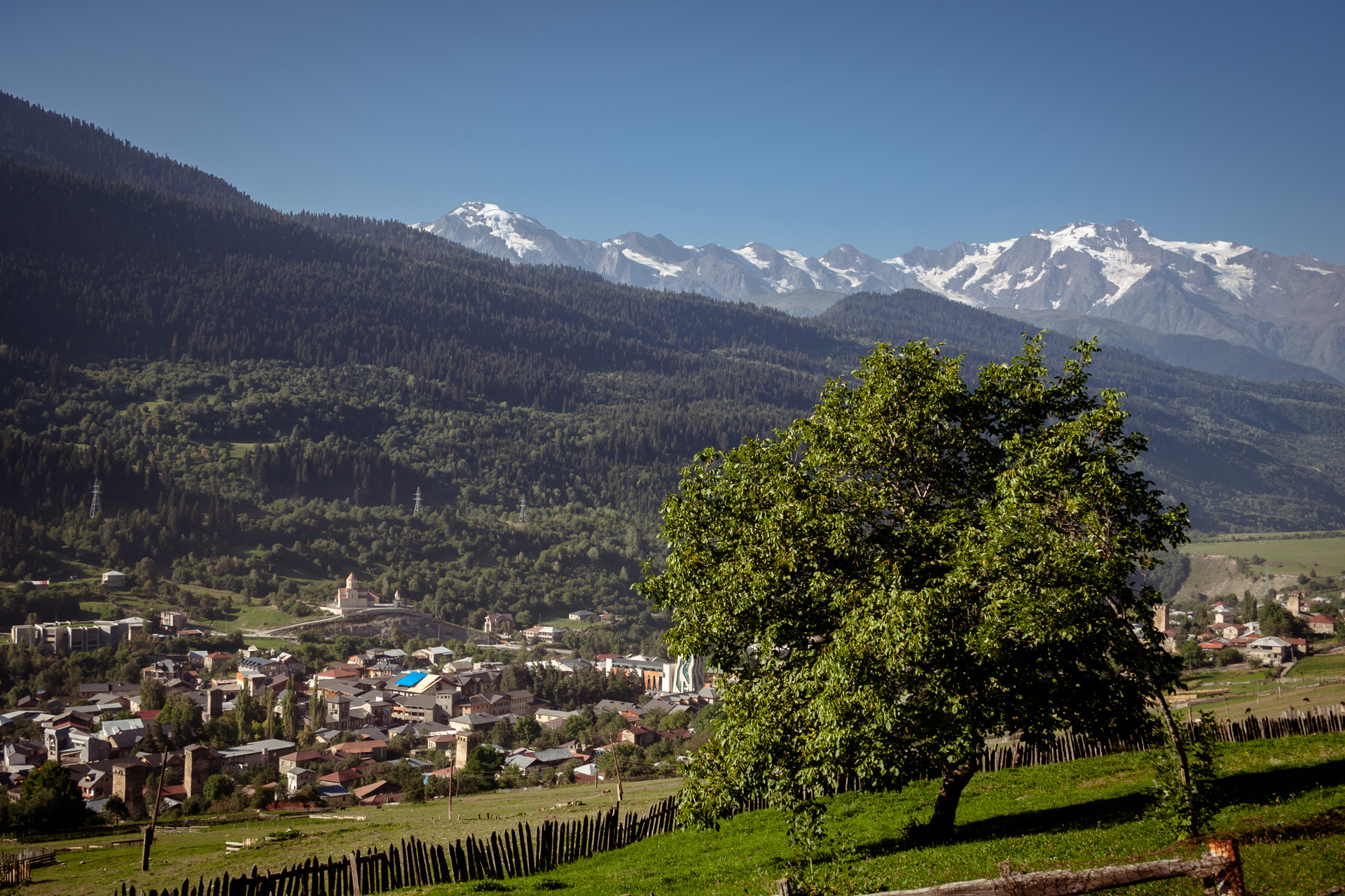
Source View of Mestia
The churches carry a lot of history such as the Gold icon of saint George that was prepared for the anointing ceremony of Queen Tamar. There are approximately 25 family churches in the villages of Svaneti among which many are found in the hills far away from the highways. A unique and a rare church that is offered to Jonah the prophet is one among the oldest churches and the church is active even today. A 11th century church is found on the top of a hill with a chappel consisting of four wooden columns. The church is called as the Matskhvari church with some classic frescoes on its wall. There are many icons and crosses in the church that are made of some valuable metals, where some have the faces of the saints engraved in it. The archangel temple that is found in the village of Tanghili is the only church that has a dome in the entire Svaneti region. There is a very little church called as the Church of Jgrag which has the oldest Georgian frescoes named as The Nativity. There are numerous paintings and engravings of different saints found in this church. In the church of Nesguni which is located in the village of lengeri are found some ancient frescoes works dating back to the 10th century. It is the only church in the Georgia where you find the image of Saint Maxim, No other church in Georgia has his image or a frescoes. The church at Ushguli which is the highest settlement point of Europe has a numerous churches each with some special engravings and icons. Most of these ancient icons and crosses are kept in a church called Chazhashi Church and the rest are taken to the museum in the administrative center. Theodore who was considered to be a royal painter of the King David the fourth painted three churches in the Svaneti region at different time periods. The churches are Ipari, Kala Lagurka and Nakipari Jgrag. The archangel church found in the village of Ipari is also known for its number of ancient icons and the paintings in the facade as well as the frescoeses dating back to the 11th century. Another important church in this region is the church of Lagurka which in Svan language means the Holy Place, the church has some special occassions when all people from the entire western part of Georgia gather at this church. At the distal end of this church on a bank of a river there is another small church called as the church of Martyr Barbara built in the 12th century. Nakipari church which was also painted by the great royal painter Theodore has some unique icons, frescoses and crosses out of which an icon that has engraved Saint George is considered to be a special one. There is also a goledn chalice in the church in which during holidays Svanetian brandy called Rakhi is given to some selected guests.
So if you visit Svaneti you should of course hike in some of the adventurous trails in the caucasus and then have a glimpse of some ancient churches on the way. From all these above mentioned facts you could now very well understand that Svaneti is a beautiful region located in the Georgian Caucasus that gives you a splendid memory and at the same time provides you with full of adventure to cherish for the rest of your life. Until I post my next article about some interesting place or an experience, bye and cheers..! :)
Content available in other languages
- Español: Admirando los Alpes georgianos
- Français: Admirer les Alpes géorgiennes
- Italiano: Ammirando le Alpi Georgiane
Rate and comment about this place!
Do you know Svaneti- The Mighty Caucasus? Share your opinion about this place.