Camino de Santiago between Coimbra and Mealhada
- Address: Praca do Comerço
- Tags:
 What to see Coimbra,
Coimbra,
Portugal
What to see Coimbra,
Coimbra,
Portugal
- Telephone: 239 488 120
- Website: http://turismodecoimbra.pt
Taking advantage of the Camino de Santiago

Lets continue talking about new hiking trails. Taking advantage of the fact that Coímbra can be found inside the Portuguese trail of Santiago, I thought about it and I said why not. For those who don't know, although the most famous route is the Northern one which goes from Irún to Santiago de Compostela, there are many other trails of Santiago, like the Portuguese trail. As the name indicates, it starts in Portugal, specifically in Lisbon, and it passes through Coímbra until it arrives at Porto.
How to arrive

To get to this stage of leaving Coímbra, we first must get to Coímbra. That is to say, either by bus from the company Rede de Expresos or by train, either urban, regional or Alpha Pendular.
If you are an Erasmus student and you fancy doing this, from Lisbon the best thing to take is the bus, in the case of Porto it is by train, in Leiria it depends, but I think it would be the bus and from Aveiro it is the regional train.
General information
The distance between Coímbra and Mealhada is around 30km, the route is practically urban, with the exception of a part of Santa Luzia, there are parts of motorway but in general it is correct.
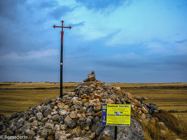
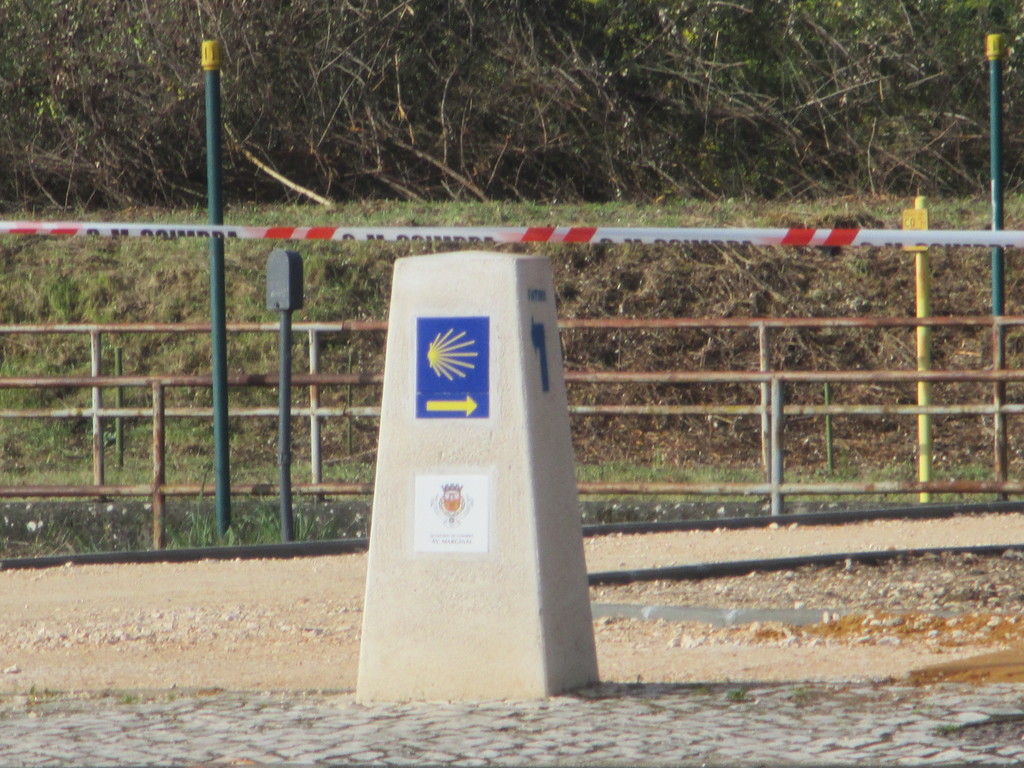
Without a doubt, the sign posting is very clear in Coímbra. There will be plaques that can barely be seen but there are also yellow arrows that indicate the whole route correctly, and blue plaques with symbol of the Camino de Santiago.
The walk is relatively simple, the difficulty lies in doing the 30km that I don't think everyone can do.
The road can be done the other way around because in the opposite direction, there is one of the Caminos de Fátima, so we will see both yellow arrows of the Santiago route and the blue arrows of the road to Fatima.
Even though I had a map, I didn't use it at all. Sometimes it seems like you might have made a mistake because there are no signs, but it is simply because the road is just straight.
The route
Although I could've left directly from the city of Coímbra, I decided to start a little closer to where I lived even though it was a little bit of a detour. At 9 o'clock on Saturday morning I started at the "Largo de Portagem", a small plaza where there was a small statue dedicated to Joaquim António de Aguiar who was a minister that Portugal had. He was born in Coímbra, and that is the reason that there is a statue in his honour.
Lets go towards some stairs and if we pay attention, we can see the sign, the symbol of the Camino de Santiago.
Continuing on, let's follow the signs towards arriving at the "Praça Comerço". This place serves as an antique market and for small events in Coímbra. The reason for the detour is so that we come across the Santiago Church and the San Bartolomé Church, which is a little smaller.
Both of them I will dedicate an article to. Continuing on, we shall go towards one of the alleyways towards the "Praça 8 de Maio". This receives its name from the 8th May (but of the year 1834) when the liberal forces entered the city of Coímbra.
In my opinion, this place is home to the most beautiful church which is called Santa Cruz. You can see it at practically any hour. The exterior and the interior is full of tiles and is two works of art. Apart from this, there are other places that a pilgrim should not miss, like the Old Cathedrals and the New, all the parts of the University, which is a UNESCO Cultural Heritage Site, and other places that I'm going to be explaining to you little by little.
From la "Praça 8 de Maio", we shall go straight on towards the "Rua do Sofía", the street of knowledge that was the longest in Portugal until the 19th century, and of Europe until the 16th. There, we can find other, smaller churches like that of the Church del Carmen that was restored not too long ago.
When the sign tells us, turn towards the left and go straight on to arrive at the "Fernão de Magalhães" Avenue. Fernão de Magalhães travelled around the world and, being a Portuguese, his name is found in practically most Portuguese cities.
This place is the financial district, with its large buildings and its wide avenue. From the avenue, a few shops selling bargain books stand out, and the bus station that, if you are an Erasmus students, you will have taken a lot!
Let's cross the zebra crossing, passing by the bus station (Estação Rodoviária in Portuguese) and then we will arrive by a McDonald's. Passing the fast food shop, we will see another of the Camino de Santiago signs and we are going to turn left, passing underneath the train line.
We will be at the doors of the "Mata de Choupal", one of the most beautiful places in the whole of Coímbra. However, we will not go towards here, we are going to turn to the right and be parallel with a canal that divides the "Mata de Choupal" of Coímbra.
We will see a roundabout and we will follow straight until we arrive at the parking for the Coímbra Station-B. Coímbra has two stations, Coímbra-B and Coímbra. The first one is on the outskirts of the city and has more connections than the Coímbra station that can be found practically in the centre of town.
Let's mention the N111-1 for a moment. Although there are lots of cars, there is no problem because there is a good hard shoulder and we will go to a second path right away that is called "Rua Percelar do Campo".
It is a secondary road so it is certain that there won't be many cars, but it wouldn't hurt to put another type of hard shoulder because there is 2 or 3 km where you have to walk along here. We will pass close by to the river. For this part, we are almost parallel with the train lines. You will see crops like oranges and wine, and olives much further on.
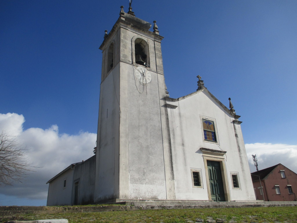
We will arrive at our first little town, Adémia, whose etymology means "fertile ground between the mountain and the lower land" and belongs to the parish of Trouxemil. All of the towns that you see here are quite small and they don't have anything from the outside world. The highlight of Adémia is the "São João" Chapel, a modest church.
There is a train station in Adémia, and it will be the only train stop nearby. Therefore, if the walk is too long for us, we could shorten it (a little) coming from this station, although there is also a station called Vilela-Fornos, too.
We will leave Adémia following the "Rua Esportina" and little by little we will arrive to our next town. On our way we will see a field of sheep and a type of stream. We will pass by "Alcarraques", but not enter it. It is one of the small towns that make up the parish off Trouxemil and Torre de Vilela.
I don't know them separately, but the villages of Torre de Vilela are formed of 1, 200 people. In Fornos, the small church "da Nossa Senhora da Esperança" stands out.
Later on we will arrive at Fornos, which belongs to the paris of Torre de Vilela. It dissapeared in 2013 in order to join with the parish of Trouxemil and to create a union between Trouxemil and Torre de Vilela.

On leaving Fornos, we will come across a bit of motorway, even though the map will sell it as "Rua Jacintos", we will pass by the IP3. I took advantage of the fact that we passed through here at 11am to have a little breakfast in the hedgerow below the IP3.
Immediately after, we are at our next town which is the famous Trouxemil. The paris of Trouxemil is formed by (apart from Trouxemil) Adémia, Alcarraques, Cioga do Monte, Fornos and Salgueirosa. Throughout the walk, we have passed by Amémia and Fornos, although you can divert towards Alcarraques and Cioga do Monte. Inside this group of towns there are almost 3, 000 inhabitants. In Trouxemil, the thing that stands out is the small Santiago Church and its cross.
Passing Trouxemil we will find the next locality of "Adões". We will leave the region of Coímbra to enter into the region of Mealhada. Without a doubt, the thing I love about Portugal is the rationing of municipalities and it is not like in Spain where the smallest town has its council.
Despite this, it seems absurd to me that Adões doesn't belong to Trouxemil when they are found right next to each other. We will also pass districts as we will pass from the district of Coimbra to that of Aveiro.
From what I read afterwards, it is even more absurd as the territory of Adões and Sargento Mor can be found divided into two different councils. The one which takes you to a part of Sargento Mor and Adões is the bus that I arrived on from Coimbra (if you are tired it is your last chance until Mealhada).
The Chapel "da Nossa Senhora do Livramento" stands out in the town of Adões, from the 19th century. It is quite a simple church like the rest of the towns. There is a church that stands out in Sargento Mor as well.
Apart from Sargento mar, we will go up little by little until we leave the town and go on the motorway once again, the N1 this time. There is a hard shoulder but with seeing trucks pass by, is not the best place in the world to walk until we get to Santa Luiza. Santa Luiza can also be found divided, part of it has the parish of Barcouço belonging to Sargento Mor and Adões, and on the other side there is the Souselas parish belonging to the district of Coímbra.
In Santa Luiza you can get confused, as many maps indicate that you should go straight on, but it seems like it changed every second and decided to take us through a small wood. Following the signs, we passed behind the Santa Luíza Chapel which was, without a doubt, built in the 20th century. We continued straight and we went through a wood. If you want, you can take a detour and go through Barcouço to see its small cathedral from the 18th century.
I had a little problem as I made the trip because it rained the day before and so the pathway was ruined by all of the cars going down it and forming huge puddles of water. I think that it should be made into asfalt, seeing as it is the Camino de Santiago. Luckily, you can dodge these puddles as there are open tracks found next to these little "natural pools".
The route will include dodging them, so if you are not in a hurry I think another day would be better. Although, I didn't get dirty or step in any puddles, but I am a little late. Finally, we will arrive at the CM1344 and continue on the right. If we fancy it, we can turn a little to the left to go to Rio Covo, which is the smallest village and practically uninhabited all year.
Continuing on the CM1344, which barely has a hard shoulder, we will soon arrive at the town of Mala. There is a fountain in Mala that can be seen once you enter, and as a lover of abandoned places, the abandoned halt of Mala is a highlight too.
A few years ago there was a train that went between Pampilhosa and Figueira da Foz. In 2009 it stopped its trips due to dangerous circumstances and they thought about improving it. However, in 2011 and the economic crisis, they decided to stop the line. The roads are no longer there as they were removed in 2013 in order to prevent people from stealing them.
We will return to walk a little more on the motorway, the M616, and we will arrive at the small town of "Lendiosa" where there is only a church to see. Continuing on little by little, we will arrive at "Vimieira". The highlights of Vimieira include the 19th century "Nossa Senhora da Apresentação" Chapel. I took advantage of this moment (around 1:30pm) to have my lunch as there were some banks and shade.
I followed the final pathway, passing through quite a pretty lane, with the exception of the last part because it had been destroyed by a tractor and therefore was full of puddles until we arrived to the outskirts of "Casal Comba". Casal Comba is a parish of more than 3, 000 peoples and includes these towns (as well as Casal Comba): Pedrulha, Vimieira, Mala, Ponte de Viadoures, Lendiosa, Carqueijo, Silvã. We have visited Mala, Lendiosa, Vimieira and Casal Comba.
Once we have arrived at Casal Comba, we are going to turn to the right and we will then arrive at a small children's park. We will continue in a straight line and then we will come to a motorway ring road of Mealhada. Mealhada has 4, 500 inhabitants and can be found halfway between a city and a town.
In Mealhada, the most touristy thing to eat is the "cochinillo", the pork. I have not tried it but from what I have seen, it is very famous and costs around 10 euros. Inside the town, it's nothing out of this world but it has a small historical centre which stands out on one side, and the Santan Church (although it has other churches built in the 20th century). There are also different modern buildings which are totally abandoned and not cared for.
With this I will conclude my route of the Camino de Santiago between Coímbra and Mealhada. On the return we went to the station. On Saturdays there is a regional train to Coímbra every 2 hours approximately. It costs 2. 10 euros but if you are under 25 years old it will cost you 1. 75. We went past four or five stops and then we were in Coímbra once more, finishing our journey through the northern parts of Coímbra.

Photo gallery
Content available in other languages
- Español: Aprovechando el camino de Santiago
Rate and comment about this place!
Do you know Camino de Santiago between Coimbra and Mealhada? Share your opinion about this place.