Madrid's Cercanías Network
Translated by  Alison Isherwood
— 6 years ago
Alison Isherwood
— 6 years ago
Blog: Translation blog by Alison in EnglishTags: General
In a previous post (currently in Spanish), I spoke a little about Madrid’s metro, how it works, the characteristics of its lines and other information that I considered to be of possible interest. All of this information can be found on that post.
But today, I am going to talk about another mode of transport that is quite important for getting around not only the city of Madrid itself, but also around the rest of the community of Madrid, where surrounding cities are connected to the capital.
The Red de Cercanías (network of Madrid’s suburban trains) is the best way by far to get to these cities for a trip (whether you go to Escorial or to other places of tourist interest, such as Alcalá de Henares) or to travel inwards into Madrid for all the people who, like me, make a living in the city of Madrid but live in one of the surrounding cities (which, in my case, is Alcalá de Henares).
But the Cercanías network is not only useful for travelling over long distances. If a topped up public transport card is available, you can use the Cercanías network at any time and to all the areas you want. In this way, it can also be useful to get to places within the city of Madrid that are better connected by Cercanías than by Madrid’s metro network.
Cercanías zones
Both the Madrid Metro and the Cercanías are governed by zones throughout the entire community of Madrid. Although the underground only reaches zone B3, the Cercanías network can reach zone C2.
The further the area that the Cercanías connects you to, the more money you will have to spend for a single ticket, so I always insist that topping up the public transport card is the best option, without a shadow of a doubt.
The zones that the Cercanías trains run in are:
Zone 0, which encompasses the entire downtown area of the city of Madrid.
Zone A which are the living areas that are immediately next to the downtown area (such as Vallecas, for example).
Zones B1 and B2, which encompass municipalities much further away, such as Alcobendas, San Sebastián de los Reyes or Coslada.
Zone B3, which will bring you to the cities that are approximately 30 kilometres from the centre of Madrid (Alcalá de Henares o Villalba).
Zones C1 and C2, which are the most remote areas and which include cities such as Guadalajara, Cercedilla, El Escorial... which are very far away areas.
As I said, the cost of moving between zones varies, there is no fixed ticket price that determines how much it costs to travel in a Cercanías train. Therefore, moving between stations that are in zones B1 and B2 will not cost you the same as moving between zone A and zone 0, for example. In the same way, travelling to a zone C, by any means of transport, will be much more expensive than moving between B zones.
All this is configured and calculated according to the distances that the tram travels between each zone. The price calculation is carried out directly by the machines to buy tickets that are in each Cercanías station but, being a bit more complex, here there are still offices to buy tickets from as, for many people, it is still preferable to ask for the ticket directly from a person before a machine.
Map of the Red de Cercanías
The Cercanías map is, of course, much less messy than that of the metro, more than anything because there are not as many lines that intersect with each other and it seems to follow a much more logical route.
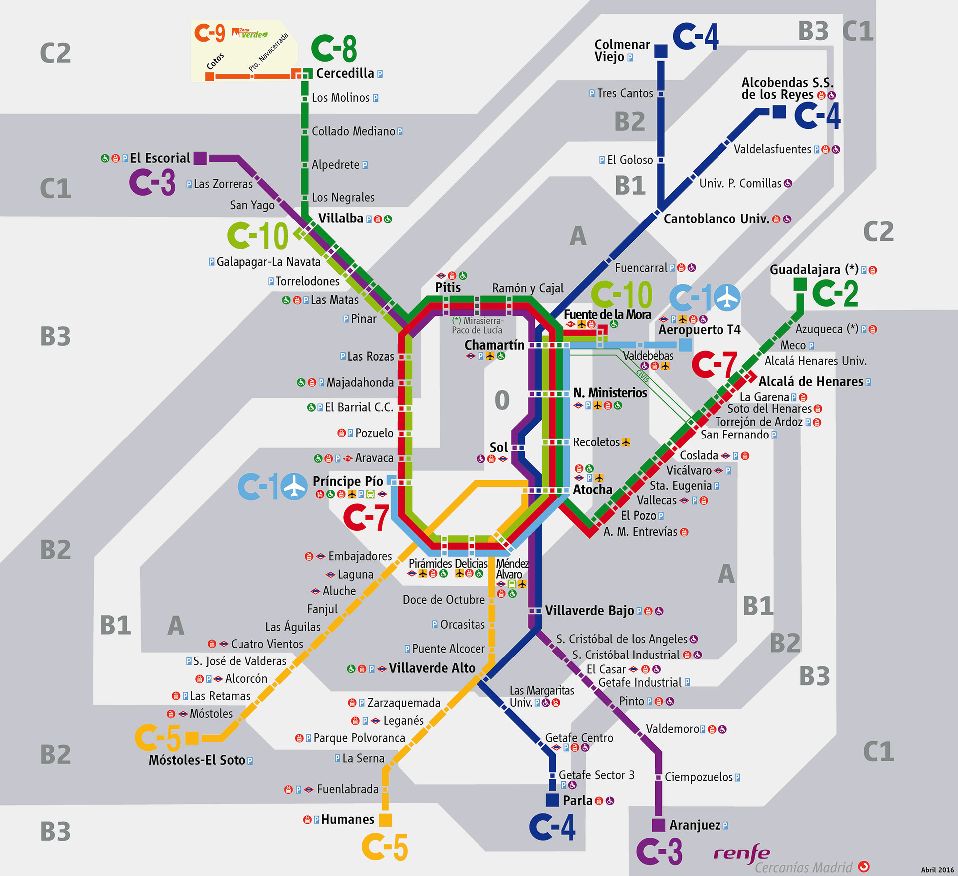
Just like with the metro, there are a few stations that are the main stations, the centres from which the rest of the lines, such as Avenida de América or Sol, expand out from. It’s very similar to the Red de Cercanías. In this instance, the stations that are most important are the Nuevos Ministerios and Atocha stations, the latter being the only one that connects to all other Cercanías lines.
And the Cercanías lines are not few in number because, in total, the Cercanías train network has a total of no more and no less than 10 lines. One can imagine the magnitude of a station like the one of Atocha, without having to see pictures, as it has to be able to house so many lines of Cercanías in a single station. Yet, despite this, Atocha is not a station that is difficult to get around and orientate yourself in the right direction.
Lines, characteristics and recommendations
I have personally used almost all of the Cercanías lines from experiences such as having to travel to the university, and for leisure reasons regarding some kind of excursion to some place near the city of Madrid.
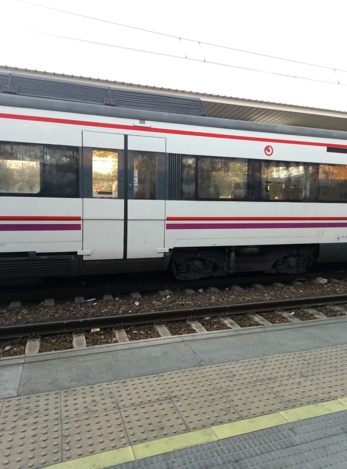
The trains of the Cercanías network are half-renovated. You can find a train with a new, remodelled design as easily as you can find a train that is not acclimatised, that is dirty or that breaks down every two or three stations.
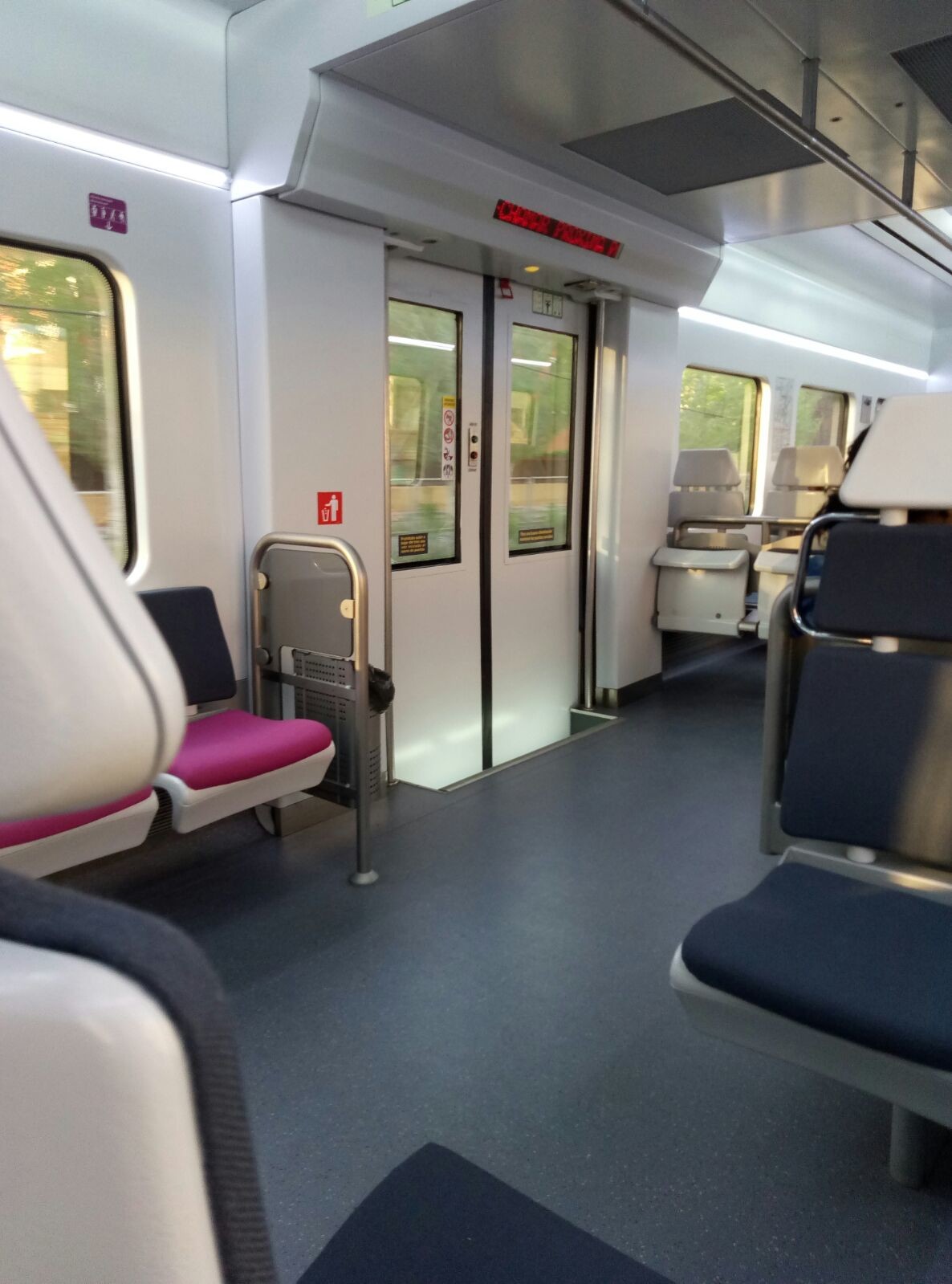
A train car that is one of the newest ones.
Line C-1
This line is the Cercanías line that is responsible for connecting the city with the Madrid-Barajas Adolfo Suárez Airport. It runs from Príncipe Pío station to the airport station, specifically to the airport's T4 terminal, the most modern terminal.
It is a short route compared to the other lines and it moves through practically all the Cercanías stations that within the city of Madrid to the airport.
I always use it for when I want to go to Principe Pio station or any place nearby, but it was created specifically to take travellers to Terminal T4 at the airport. Nowadays, it is a project that has failed a lot as it does not have the expected influx, nor does the Nuevos Ministerios station have the importance in terms of prior check-in to arrive at the airport that was originally planned.
Line C-2
This is one of the lines that I have used the most, since it is the one that connects Guadalajara to the centre of Madrid. When connecting Guadalajara, it goes through Alcalá de Henares, so I have used it a lot since before I can remember.
It is one of the lines that travels the farthest, since it goes from the city of Guadalajara to the city of Cercedilla, which are practically at opposite ends to each other.
Line C-3
Another of the longer routes, this line is responsible for getting you from the city of Aranjuez to the city of El Escorial.
I, personally, have never been to Aranjuez in Cercanías, but I have gone more than once to El Escorial, which is a highly recommended trip because it only takes half an hour to get there from the centre of Madrid and it is a beautiful place.
Line C-4
A line that goes from south to north. From the city of Parla to the modern and wealthy cities of Alcobendas and San Sebastián de los Reyes, passing through the city centre, as do all lines.
Here are the most modern trains. At least, on no occasion have I gotten onto an old train when travelling on this line.
Line C-5/ C-6
This is a line that is divided into two routes that start from Atocha: one goes to Humanes, passing through the cities of Fuenlabrada, and the other goes to Móstoles.
The only thing I know about this line is that it also has the most modern trains, but since I have never travelled on this line, I cannot say much more.
Line C-7
This is my favorite line for no reason other than because it is the line that directly connects the city of Alcalá de Henares with all the other stations.
It is one of the lines I use to go to university, and it is without a doubt one of the busiest lines in the entire Cercanías network.

An interesting fact is that it is one of the few lines which uses double-decker trains, something that usually attracts a lot of attention from people who are not used to seeing them, but also something very necessary given the huge amount of people that have to use these trains.
As sad fact is the fact that it was on this line that all the trains exploded in the tragic attack on 11th March, 2004.
Line C-9
A short line used to connect the Puerto de Navacerrada (Navacerrada Port) with Cercedilla and the rest of the lines.
Very useful in winter when it snows, as these trains are designed to travel in the face of adverse weather.
Line C-10
The last of all lines. It runs from Fuente de La Mora to Villaba, making a detour through the centre of the almond-shaped city of Madrid.
Photo gallery


Content available in other languages
- Español: Red de Cercanías de Madrid
- Italiano: Cercanías: la rete ferroviaria di Madrid
Want to have your own Erasmus blog?
If you are experiencing living abroad, you're an avid traveller or want to promote the city where you live... create your own blog and share your adventures!
I want to create my Erasmus blog! →


Comments (0 comments)