Tongariro Nationalpark - Tongariro Crossing - Mount Doom
Published by  Nadine Schlehofer
— 7 years ago
Nadine Schlehofer
— 7 years ago
Blog: Disovering Kiwi Land on the other side ot the world: work and travel in New ZelandTags: Erasmus blog New Zealand,
New Zealand,
New Zealand
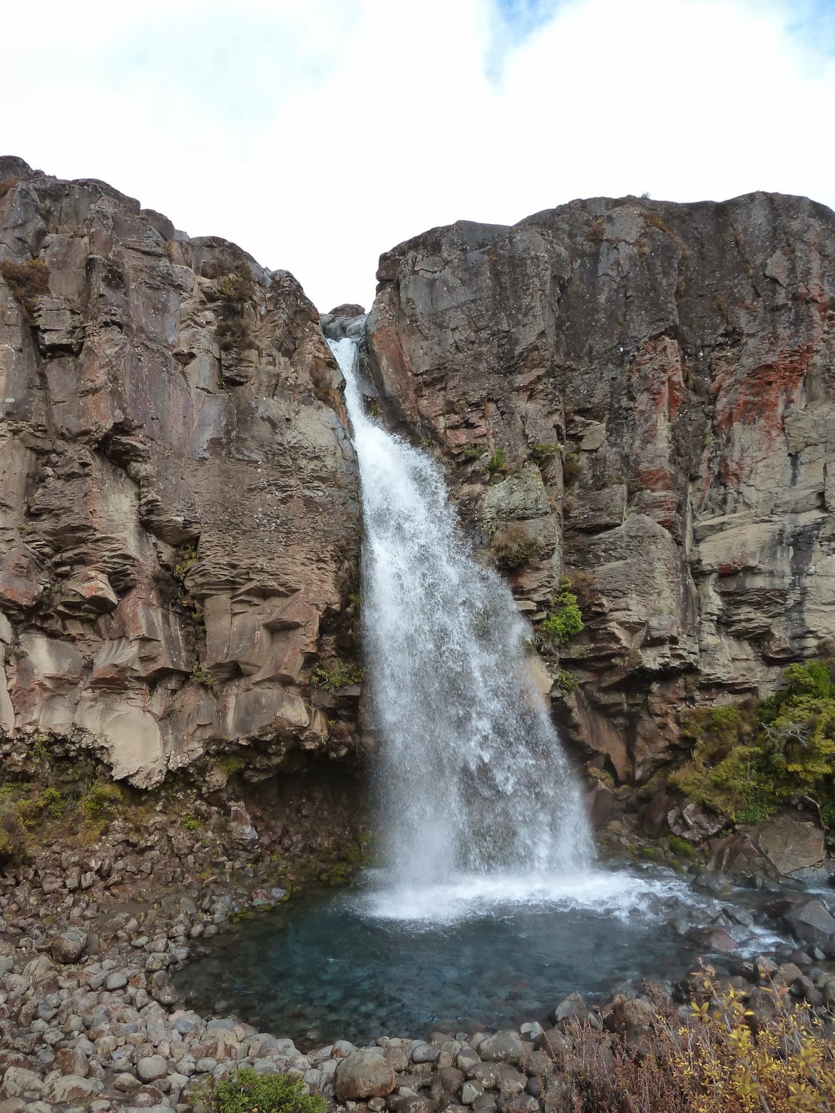
We spent one day on driving around the Tongariro National Park with our car, just to get to know the region a bit better and have some orientation. The Tongariro National Park lies between the Taranaki Region and the Lake Taupo and has the three big volcanoes from the Taranaki story that I told you in the article before. There are: the Mount Tongariro (1978m altitude), who gave name to the national park, the Mount Ngauruhoe (2291m altitude), who had the important role of the Mount Doom in the Lord of the Rings Saga, and the Mount Ruapehu, who is with 2727 metres the highest of them. In this region, many scenes from the Lord of the Rings have been shot, many of them including the Mount Doom, some scenes in Mordor and the wetlands of Emyn Muil. Here, I should mention once again, that I am a big fan of the Lord of the Rings and therefore, will always refer to it. So, we enjoyed the landscape and the skiing area of Mount Ruapehu and did two short hiking trips to the Taranaki Falls and the river Whakapapanui (spoken Fakapapanui). Because we had to get up early the next morning, we didn’t do any exhausting hikes and also went back home early to relax with some chips and a hot cup of tea on the terrace, where you have amazing views on the stars.
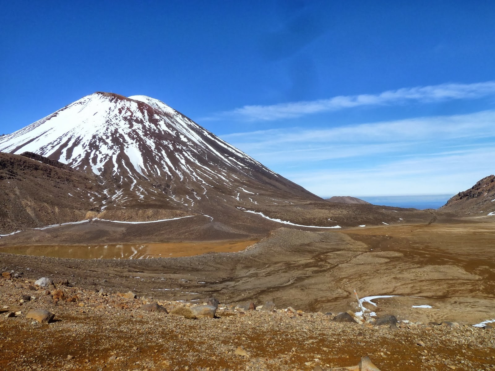
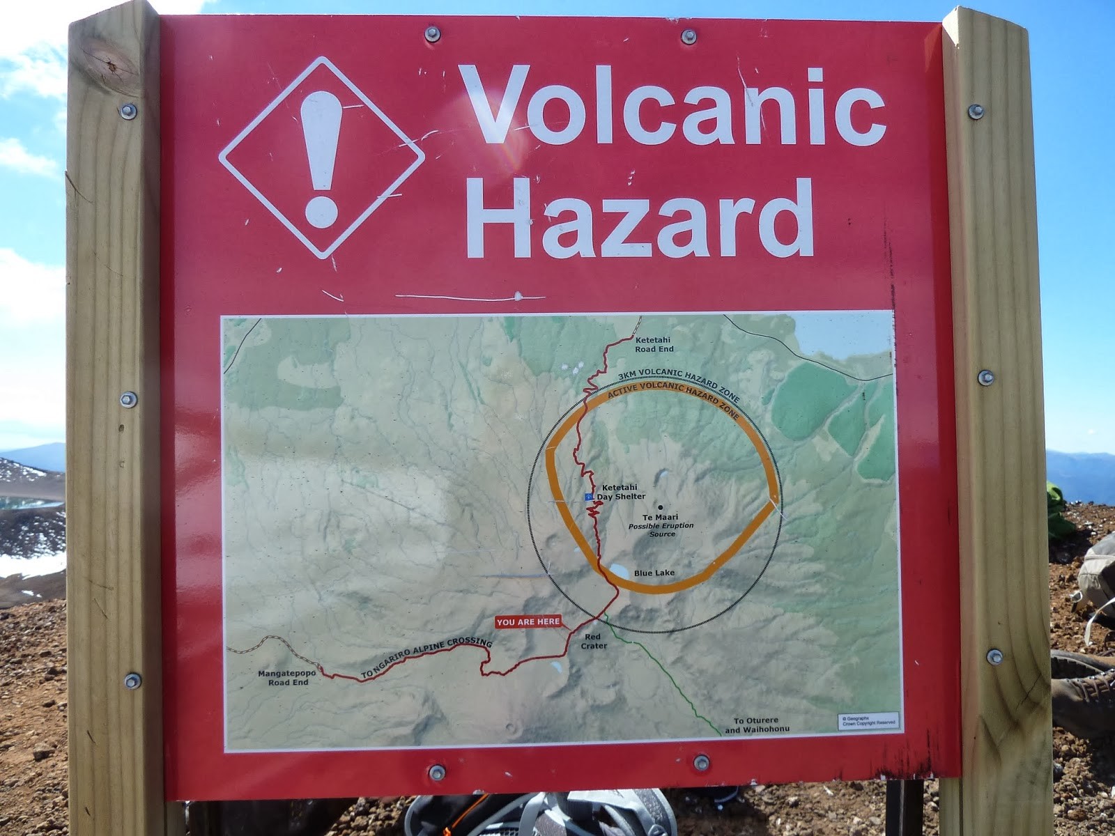
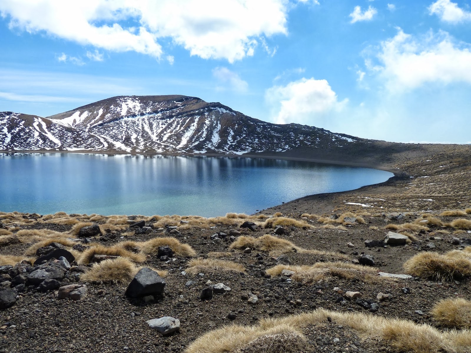
The next day, we got up at six o’clock in the morning, had breakfast, prepared our provisions and got ready for a long day. The shuttle bus came to get us at 7 o’clock and drove us to Mangatepopo, where we started the Tongariro Crossing. The weather was a dream, no clouds and the rising sun was already warming our faces and so, we started very motivated. It would take us 7, 5 hours and 19, 7 kilometres to cross the mountains Ngauruhoe and Tongariro. We hiked the Mount Ngauruhoe steadily upwards to the Red Crater, while the sun was rising higher and higher. Shortly before the highest point, came the hardest part was artificial, steep stairs. Up there, everyone had completely red faces, was breathing heavily and took off all clothes that weren’t needed. The sun and the effort made us sweat like in summer. There we continued the steep and very slippery way down and then on the plateau past the Emerald Lakes to Mount Tongariro and past the very active volcano Te Mari. This one had erupted the last time in august 2012 – about one year ago – and until march 2013 the road had still been closed for security reasons. Before starting the route, we had to read a lot of safety instructions. There, it was written that we have to be aware that the weather can suddenly change and therefore, good hiking equipment was necessary, but also about the danger in the “active volcano hazard zone”, where we should stay as less time as possible. Instructions for the case of an eruption were: citation “Just do it like the ork in Lord of the Rings in the battle at Helmsklamm, standing, observing the flying stones, waiting and shortly before it falls on you, step aside. ” Firstly, I immediately liked the guy, because he referred to the Lord of the Rings and secondly, we noticed soon that there would not be many other options. The not joking version was: Get out of the hazard zone as fast as possible, not show our back to flying rocks or lava balls and to hide behind big rocks. Hearing that, I was a bit worried and was rethinking the whole expedition. But, we already had heard so many people talking about the amazing trip and we really wanted to do it. And it was so worth it! The sun shining on the snow tipped mountains, the turquoise lakes and knowing than deep down, there was an active volcano bubbling, made this journey unforgettable. The imagination that this seemingly, very calm Mountain, with snow on it’s top, highlighting its contours, was used as the very dangerous Mount Doom didn’t work out for me. The two images were just too different, but anyhow, you could see the similarity and try to imagine that this is Mount Doom many years after the happenings of Frodo and his companions.
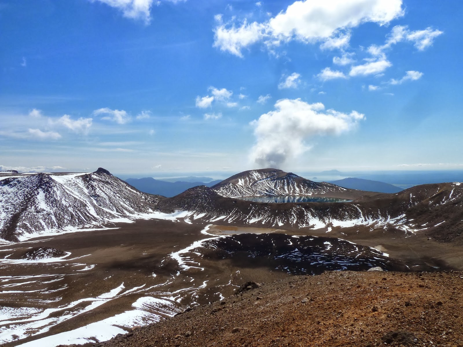
Even the many bladders and tiredness could not darken my happiness about the breath-taking landscape and experience. From the top, we were able to see the big lake Taupo and on the other side the Mount Taranaki as well as the sea. In the hazard zone, we didn’t stop, but after it we had a short break, ate and drank a lot. This was also the only place, we you could find toilets. Then, the way was still long, but it was only going downwards. Long ways through a jungle like forest. We had to cross some rivers, saw some small waterfalls and the whole time the singing of the birds was motivating us. At half past three, we arrived in Ketetahi and had overcome more than 1100 metres elevation gain. We have been so happy, when the shuttle bus got us at four to bring us home. We just wanted to go home and sleep, it had been a really exhausting day. Not even the almost-accident with a -obviously European – driver on the wrong side, woke us really up. Arriving at home, we took a long, hot shower and treated ourselves with very good food in the Spiral Café, which had been a recommendation from our dear friends. And the burgers were indeed especially good. Sitting on our beds, with once again a cup of tea – already true New Zealanders – we talked about the nice day and then the next day, where we already had plans to continue.
Still today – more than three years later – I have to say, that this crossing was one of my highlights.
Photo gallery
Content available in other languages
Want to have your own Erasmus blog?
If you are experiencing living abroad, you're an avid traveller or want to promote the city where you live... create your own blog and share your adventures!
I want to create my Erasmus blog! →


Comments (0 comments)