Today I am going to talk about one of the most popular hiking trails, the old railway line that passes through Villalonga and Lorcha. It is a 12km walking or cycling route and can be prolonged by the addition of 30km if you choose to arrive in Muro in Alcoy.
How to arrive
From Gandía there is a bus to Villalonga costing around 1. 50€, the timetable changes almost every year so therefore, I would recommend that if you are catching the bus then don't trust what it says on the internet and go directly to the bus station, where the train station is also located.
You can come to the train station from many parts of Valencia and afterwards, you can get anywhere else on the bus. Then, from Villalonga we will take a pathway up to the start of the trail.
A bit of history
The original purpose of the train was to be a communication link for a series of reasons, the industrialisation of the Valencia community had occurred in the mountainous areas such as Onteniente and Alcoy.
Alcoy used to be called the little Catalonia as it was a small forum for textiles but, as I have indicated, the mountainous area meant that they had to think of a way to transport their textile products. The best thing to do would be to create a railway that followed beside the river Serpis (o river Alcoy) that met the sea at Gandía. The inagural journey took place in 1892 and the railway continued running until 1969.
The reasons for its shutting down were due to the fact that Alcoy was slowly becoming an industrial hub and the appearance of asphalt motorways meant that the train was no longer needed. As well, the necessity for growth in Alcoy, Concentaina, Muro and Gandía meant that it impeded the train's route.
It would have been interesting to modernise the railway line, I think it would've been profitable if it were to have been modernised, as well as with the growth of tourism in the '70s, Gandía would've had very good clients looking at the interior regions.
The trajectory of the train between Alcoy and Gandía linked all of the all populations between the towns of Alcoy, Concentaina, Muro de Alcoy, Gayanes, Beniarrés, Lorcha, Villalonga, Potríes, Beniarjó, Gandía and Grao de Gandía, a total of 52km and 2. 5 hours.
For those who are interested, I'm going to talk a little more about the trail, starting at a semi-abandoned station in the port of Grao de Gandía that I think is fenced off now, it was used as a restaurant for many years before this.
Afterwards, it continues on the actual railway line to the surrounding areas "Grao and Gandía beach" and enters through Benisuai street and carries on to the old station of Gandía which is totally restored and can be found used as a library.
Some tools are exposed in the Station Park like the fuel tank (which I will speak about in future articles) and the train engine, a nº 7 "Concentaina". The trail leaves from the Alcoy railway and turns towards Refelcofer street where it continues straight down, crossing a bridge over the river Serpis in the direction of Almoines.
According to a census in 2014, Almoines has 2, 300 people in it, along with a restored train station and the headquarters of the Gandía-Alcoy Railway Association. There is also a museum which focusses on the history of the railway and a mini reenactment of all the stations along the trail.
The train continues through Beniarjó where you can find a restored house (although quite different to the original) next to the line. Beniarjó has a population of almost 1, 800 inhabitants and its etymology is a bit problematic, but I'm sure that it is Arabic, and it could maybe stem from the words "Bani Zarjun" which means "children of the vine".
Continuing on, we have the population of Potríes, who's station no longer exists except for the ruins of the shelter, which has a broke roof. It is a shame that the local government has allowed it to degrade over time.
Potríes has almost 1, 000 inhabitants and its etymology comes from the Latin word "pottus" which means "bottle" and probably comes from "poteries" in French.
After this the line goes through Villalonga by the motorway, this station no longer exists either as it was knocked down in 1994. Nowadays you can find the "Vall de la Safor" institute here - Villalonga has an easy etymology as it simply comes from "villa larga" (longa in Latin) which means "long town". It is one of the towns in Safor that has the largest amount of inhabitants, with exactly 4, 350 according to the census of 2014.
Let's continue through "Hell's Canyon" or "The Duke's Corner" where even though many bridges have disappeared, their remains are left, along with some tunnels. I will be talking a little more about this bit.
We will arrive in Lorcha, the first municipal town in the regions of Condado de Concentaina, a region that is not densely populated. Lorcha (or L'Orxa in Valenciano) has little more than 676 inhabitants and the place name is surely derived from the pre-romance word "Urci".
The station has been conserved but it is totally closed off with the hope that one day they can make it into a utility or at least restore it, I personally would put a Tourist Info point there, it being part of the most famous hiking trail and all.
Our next stop is the town of Beniarrés, known for having a reservoir that is used when the Serpis river goes dry. It had 1, 254 inhabitants in 2014. The station disappeared and was founded again as the CEIP Perputxent. The main exports of Benibarrés are based around wine and olives. Inhabitants continue with Gayanes (Gaianes in Valenciano) who's etymology could come from the Latin word Caius. It has a population of 445 inhabitants and the only thing here is a maintenance house and the station which has also, sadly, stopped existing.
Next we arrive in Muro de Alcoy (Muro d'Alcoi in Valenciano) who's wine and olive oil were the main products that this city, a city that has almost 9, 000 inhabitants (according to the census in 2014), exported most. The name comes from the latin "mur" and then brought through time as a Mozarab word.
The name Alcoy is not for the municipal town of Alcoy, nor for the river of the same name that is also called the Serpis. Luckily, the station has been restored since the '90s as a cultural area called "La Xafigà". It is the most beautiful of all the restored stations, that is to say regarding those of Gandia, Almoines, Beniarjó and the "abandoned" ones in Lorcha and el Grao de Gandía.
Our penultimate stop is the capital of the county (or "El Comtat" in Valenciano), Concentaina, possibly belonging to Contestania, an ancient territory that occupied part of the Valencia area. It has more than 11, 000 inhabitants according to the census of 2014. In older times, they exported textiles and paper from the factories. The station here is also run down.
Lastly, we have Alcoy, the capital of "l'Alcoià" (or Valley of Alcoy). Its name is derived from the Latin word "collis" which means little mountain, or "montañita" in Castilian Spanish, and it is joined with the Arabic prefix of "al". It has almost 60, 000 inhabitants and exports textiles, paper and iron and steel, as well as most importantly they import carbon from the UK.
The station also can be found run down and was in the old Plaza Al-Azraq. In its place, the old engine "Villalonga" Number 2 can be found.
source
The trail
Once the towns have been named, the route can be walked, which is the most recommended between Villalonga and Lorcha which are around 12km, but if you go by bicycle you can increase the journey to 30km to arrive at Muro de Alcoy. I don´t know if there is a bike lane between Muro de Alcoy and Concentaina or even a path, but it will not be the old railway track of Alcoy.
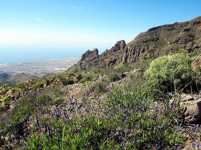
The success of this trail is due to the fact that there are hardly any slopes after the beginning, and the possibility of entering the tunnels and the enchanting landscape such as Hell's Canyon or The Duke's Corner.
From Villalonga we will be on our way, passing by the Vall de la Safor Institute where you can find the old station. The walk is labelled as "Via Pista" and we will need to go to the old quarry.
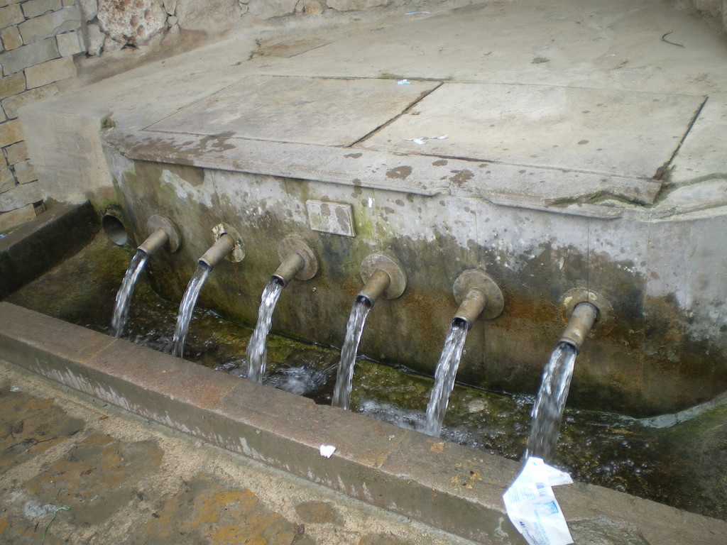
For this, we first need to pass by a fountain (which is not safe to drink from, if I am not mistaken) and we will arrive at the quarry, where there is a hill. By the quarry we will continue walking through a path full of trawlers (which I guess are a little illegal). It is easy to find the quarry and the start of the path, which is normally full of cars as it is quite a famous route.
We will find a sign that tells us that this is the Lorcha route. Throughout the walk, the only crops we will see will be orange trees, as well as pine trees and others.
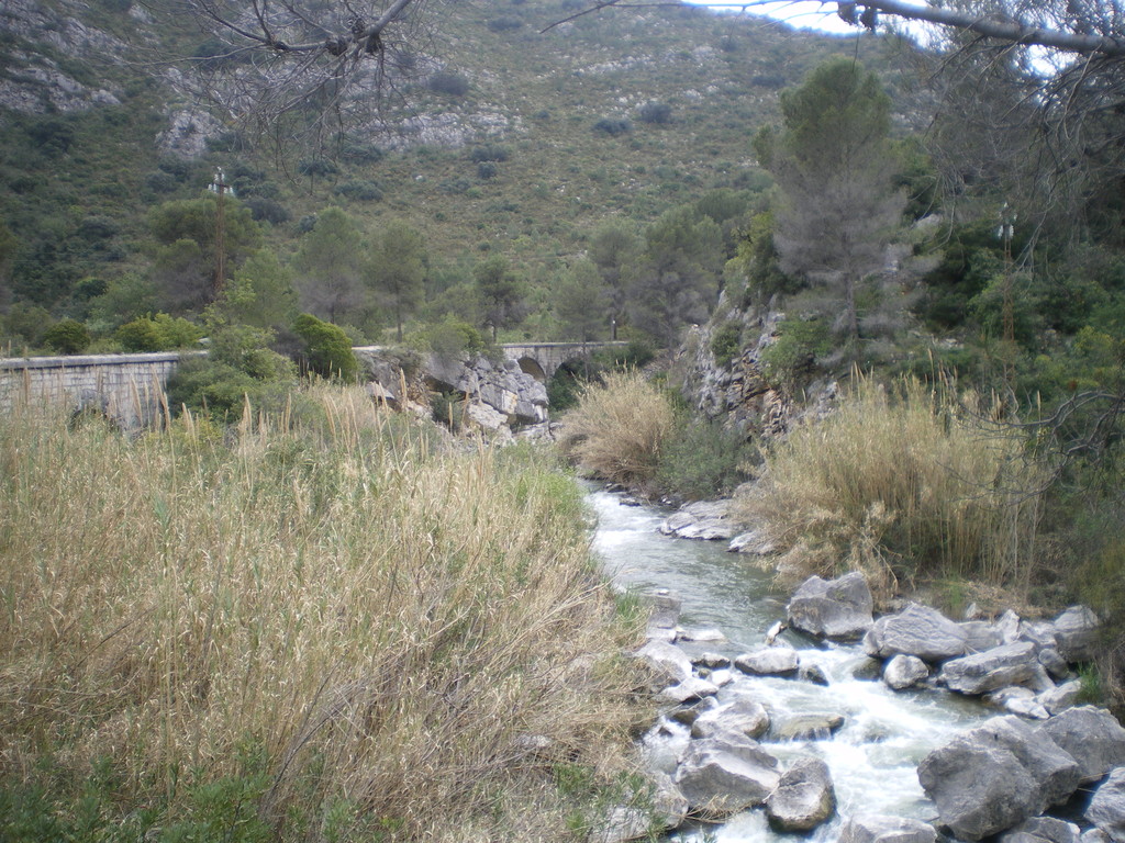
The views throughout the walk are beautiful as we will be going parallel to the Serpis river (or Alcoy river). The first interesting place along the way is the coin mill (Fàbrica del Cèntim in Valenciano) which got its name from the penny that they took from the workers every day. Unfortunately, this is actually the company of Iberdrola.
These power plants harnessed the hydroelectric power of water by creating several dams that were kind of "mini-dams" that harnessed this force when the water fell to create energy.
Close by we have the first tunnel, in total there were eight of them, five of which can be found between Villalong and Lorcha. They have a bit of light in them, although it never hurts to have a flashlight.
In the old days, the smoke from the carbon made them open up some small holes in the tunnels and those who returned to Alcoy after working inside them came back home with a face blackened with soot. This tunnel got the name of "Mina Larga" ("Mina Llarga in Valenciano) and "Long Mine" in English and it is the largest of the five tunnels.
On leaving, there is a small path to arrive at the Senén Pla Monument, a place where a lumberjack found an image of the Virgin Mary, Patron Saint of Villalonga who you can visit in the Chapel of the Virign Mary of the Fountain (Capella de la Mare de Déu de la Font in Valenciano).
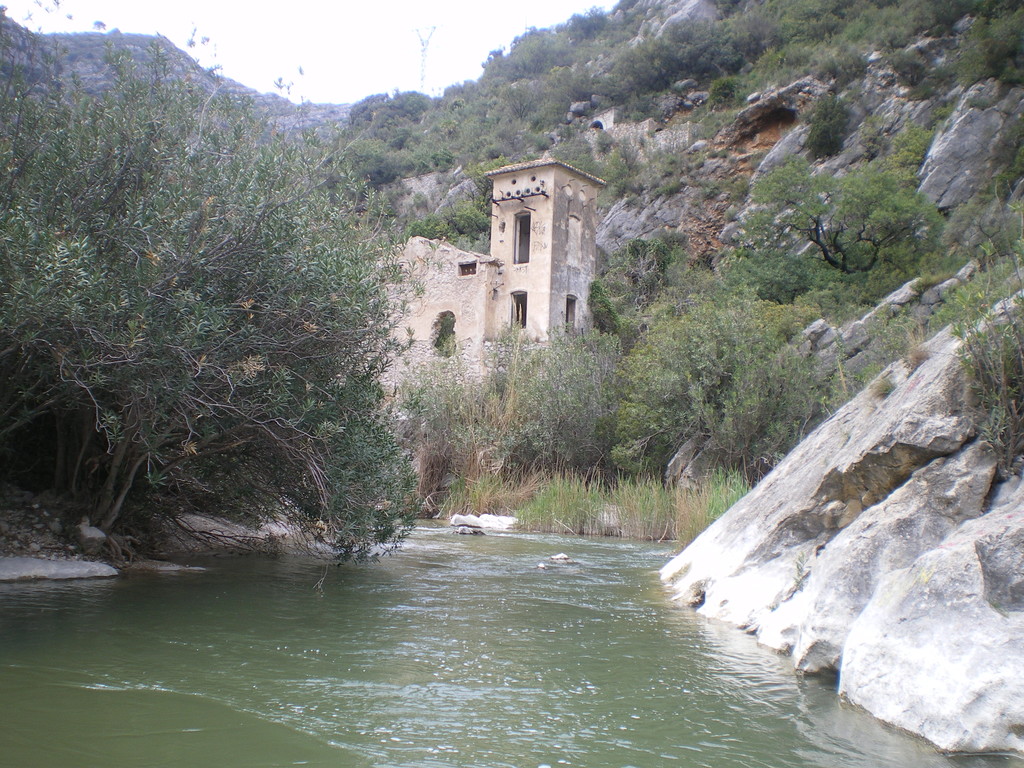
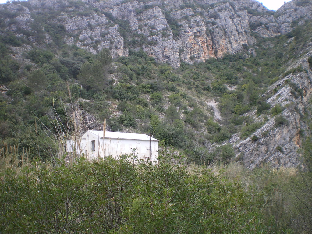
On the other side of the river, we have the mill of the Virgin Mary (fàbrica de la Mare de Déu in Valenciano) which is what you can see in the second photo. As well as the factory itself, you can find ruins of houses that used to belong to workers and guards.
Let's continue walking towards the second tunnel, the "Mina de Onofre" which is 130m. There isn't any danger from entering into these tunnels, it is pitch black for a moment but they are huge spaces (obviously, so that the train could pass through) and in a good state. Continuing on, we will se an abandoned house that was used by the old Railway line.
Later on, we will be going past a rock bridge and we will arrive at the Duke's Corner Mill. I think that it is not open nowadays, although towards the end of the 20th century it was actually reopened for the Spanish Hydroelectric Company. For this reason, it has had many aesthetic changes (that are actually quite ugly) and that contrast with the rest of the mills. A little higher, closer to the third tunnel you will find the dam of Morú which also is to create electricity.
Continuing on, the walk arrives at the small tunnel of Morú (near to the dam) of 30m. Near to here, on the left there is a path to the Mata fountain. In the past this seemed like a hard walk to me, I don't know if I have gotten used to it or my perspective has changed from when I was younger because now that I have done it once more it doesn't seem hard at all.
It is a beautiful fountain (or more of a waterfall), although it is difficult for bicycles to get here or basically impossible. I would recommend coming here only if you are going to Lorcha, but if you are going to Muro de Alcoy, you already have enough kilometers to travel.
The next tunnel is Garrofera, which in the past used to cultivate carob trees. Close to here we have the ruins of the Garrofera station as well.
Let's continue walking through this beautiful trail until we arrive at the most beautiful and biggest mill of them all in my opinion, which is the Devil's Mill. The 19th century style of the mill at the foot of the river Serpis gives it a very beautiful look and it used to produce electricity from the dam del Horno (or the Forn in Valenciano).
With the ruins of old houses close by and a small church half hidden by greenery dedicated to the Virgin of the Immaculate Conception. It was parciall destroyed during the Spanish Civil war and the figure of the Virgin was moved to Oliva. During that time, churches were important and necessary spaces for everyone.
We will pass by a small fountain and arrive at the last municipality of Lorcha. A little further and we will arrive at a deposit of water, which is the only train stop on this journey between Villalarga and Lorcha. Near by there is a pathway that leads to the Serquera Fountain, but I have never been there so I can't really say much about it.
After passing by the dam del Horno we will arrive at the fifth tunnel, the tunnel de Lorcha, 120m. On passing by this tunnel we will come across the Enmig Windmill. Made in 1843, it can be found in ruins and little is left of it now. Following the path, we will arrive at the Fountain and Millpond de Botero, a great place to relax.
Continuing on, we will arrive at another building, the cottage of the Lorcha Railway. We will see a view of the Perpuchent Castle and the station of Lorcha where this famous trail ends.
From Lorcha to Muro we will change from a more urban path to a trail, but it is not complicated to do, it passes by Beniarrés, Gayanes until it arrives at Muro de Alcoy.
The place is a mandatory stop for any hiker walking through the province of Valencia, but cars and motorcycles pass through this place as well, so try not to go during the Easter holiday (especially a Sunday or Saturday) when it is full of people, cars and motorcycles, it is so annoying!
But nevertheless, this is the trail that you have to do at least once in your life! I hope you enjoy the view!
source
 What to see Villalonga,
Villalonga,
Spain
What to see Villalonga,
Villalonga,
Spain