The historical development of the city aligned with the destructive events from past
Published by  vesela tanaskovic
— 9 years ago
vesela tanaskovic
— 9 years ago
Blog: Meraklijski-Nis south SerbiaTags: Erasmus blog Nis,
Nis,
Yugoslavia
These dominant historic and geographical features were not just influential in the city’s development and urban planning, but they shaped it in a way, alongside the different occupiers that tried to impose their own culture upon the local Serbian population. It is evident that the city of Niš developed in a way that follows the destructive path of the past, as for every battle or conquest in Niš, had been followed by the development of that particular part of the city.
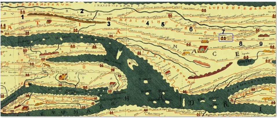
Niš being one of the oldest cities in the Balkans and Europe has from ancient times been considered a gateway between the East and the West.
Archaeological evidence shows that city was inhabited since the Neolithic times, with Neolithic settlements in the city and area dating from 5,000 to 2,000 BC; a notable archaeological site being Humska Čuka, discovered by a group of students in early 1930 from Harvard. The Paleo-Balkan Thracians inhabited the area in the Iron Age, and Triballians dwelled here prior to the Celtic invasion in 279 BC which established the Scordisci a Celtic tribe as masters of the region. A legend on how the city got its present name is connected to Celtic arrival to Nis. The legend says that when Celts arrived there was a water fairy in the river, and as fairies are, this one called Naisa was also mischiefs, and she demanded that the city and the river be named after her. So people in order to please her and make amends with her wild nature named the city Naisuss and the river Navissos, today Niš and Nišava, still honouring the treaty made with the patron fae.
Naissus, now Niš, was among the cities taken in the Roman conquest in 75 BC. The Romans built the Via Militaries in the 1st century, that lead from Singidunum (Belgrade) to Constantinople (Istambul), with Naissus being one of the key towns on the road. Niš is also notable as the birthplace of Constantine the Great, the first Christian Roman Emperor and the founder of Constantinople, as well as two other Roman emperors, Constantius III and Justin I. It is home to one of Serbia's oldest Christian churches dating to the 4th century in the suburb of Mediana, the Constantine’s villa.
Development of the city didn’t start along the fortress as one would imagine, but the fortress served more as the military ground with barracks and it had the river as natural barrier with the swamp in the area of present day city centre as protection from intruders. The city developed on the right side of the Nišava River and on the nearby hills of Vinik, where most of the city rich residence of that time had their villas and where at the time was the biggest mint in the region, if not of the whole Roman Empire. A stretch from the fortress to the Constantine’s residence Mediana all until the hill of Niska Banja, a thermal spa 10 km from the current city centre, was also inhabited at the time with more important and noble people, presumably relatives of the ruler, his fleet, his servants and military. Today we have 80 hectares of land the Constantine’s villa complex that is now a museum and is open to public that stand as a reminder of how great the Nis was once. .
Even though all this conquests and concerning has made its mark on the town and its dwellings the current city limits and its development has mainly been influenced by the Ottoman rule as they were the last to stay in the area longer than a few years.
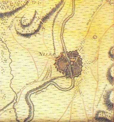
On this Austrian map from late 17th century we can see how city developed differently to what was recorded in Roman times. In Roman times the city was shaped like a “T” and sprawled along the river beds, predominantly on the right side of the river, with some housing on the hill across the river from fortress on the south side of the city.
By comparing differents maps from this period that to a later period, of Middle Ages, we can see that the city shrinked in the middle ages, which was followed by gradual expansion under the rule of the Ottoman rule.
This somewhat historic anomaly is easily explained by Nis’s strategic location between the Constantinople, Thessaloniki and Belgrade, whit it all further northern parts of Europe. All the conquests that were led south towards Constantinople or Thessaloniki would have had to pass through Nis, as well as the opposite, all the conquests led from the south towards north would have had to pass through Nis too. This is why and how in the V century, after centuries of great prosperity and progress under the Romans and later Byzantines Empire, Nis got demolished by Huns. The city was completely ruined and most of the surviving population fled the city for the surrounding hills. This was the first great destruction of the city. After some decades had past, people started to return back to the city and a new renewal phase started. Citizens believed that the city will soon rich its full glory. However not even a century had past, before a great new destruction of the city happened first by south Slavic tribes at the beginning of the VI century, then by Avars in the late VI century who completely destroyed the city. Avars were an Eurasian nomadic tribe of the early Middle Ages of uncertain origins, who established the Avar Khaganate, which spanned across the Pannonian Basin and considerable areas of Central and Eastern Europe from the late 6th to the early 9th century. After this conquest the city started to rebuilt again, however soon after it fell into Slavic hands. The south Slavic tribes were approaching the region for some time now, and had conquered the Nis from the Byzantine. For four centuries up until the XI century the battles were held between the south Slavic tribes, Bulgarians, Serbs and Byzantine for this highly strategic city.
During this time the city itself stagnated in its development, and degraded in its glory, losing its population by each new battle, not returning its royalistic importance until the beginning of the 20th century.
The city and its residence were under nearly constant siege or impact by one or the other side, but this were all minor destructions as they all had something to loose, both Byzantine and Slavs. Than in the XI century, in 1072 town was raided by the Hungarians (Ungari) and completely destroyed. This was noted as the third great destruction of the city. Manuel I Komnenos or Comnenus (Serbian = Manojlo / Greek: Μανουήλ Α' Κομνηνός, Manouēl I Komnēnos; 28 November 1118 – 24 September 1180) was a Byzantine Emperor of the 12th century who reigned over a crucial turning point in the history of Byzantium and the Mediterranean. Eager to restore his empire to its past glories as the superpower of the Mediterranean world, Manuel pursued an energetic and ambitious foreign policy. In it he fortified the town of Nis, and it has been orated in traditional poems of that time that every corner of the Nis fortress had a tower higher then the previous one. The city had never been more fortified in a way, but how it usually goes, his successor Andronik, could not hold to it, so Niš was seized by the Hungarian king Bela III.
The town was in Greek hands for short time, until Stefan Nemanja, the founder of Serbian state and the patron of the first dynasty, conquered it from the Byzantine in 1183. In this same year he renews the St.Pantalejmon temple/church, which is situated on the hill on the right side of the river Nisava, on the eastern side of the fortress. This was an early Christian temple which he renewed and is now the oldest church in the city. Stefan Nemanja planning to proclaim Nis as the capital of his newly formed state, had even received high official visits from Europe courts in that time in the church like Fridrih Barbarosa was ( the contract they signed is still kept in the church) but was unable to do so. In 1185 Nis was under Serbian control, but not for long. In 1196, Isak Angelos defeated Stefan Nemanja and it was not until 1241 that Niš was in Serbian hands again.
This brief historical overview from the V till XIII century explains that citizens of Nis after the Roman times never had one generation that was able to live their whole lives without a siege, battles or conquests of some sort, this trend more or less continues until the present day. Looking from planning point of view this influenced the development of the city, as it was constantly being destroyed, with numerous attempts to be renewed.
Both maps were taken from wikipedia both mark Nis as Naissus
Photo gallery
Want to have your own Erasmus blog?
If you are experiencing living abroad, you're an avid traveller or want to promote the city where you live... create your own blog and share your adventures!
I want to create my Erasmus blog! →


Comments (0 comments)